Britain's Drowned Past: Ancient Forests Emerge as Rising Seas Expose Our Prehistoric Heritage
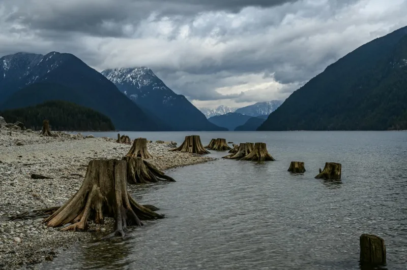
Along Britain's rapidly eroding coastlines, an extraordinary archaeological landscape is emerging from beneath centuries of sediment. Ancient tree stumps, their bark still intact after thousands of years underwater, punctuate beaches from Wales to East Anglia, revealing the ghostly remains of vast forests that once stretched across what is now the sea floor.
These submerged woodlands, known to marine archaeologists as 'ghost forests', represent one of the most significant prehistoric landscapes in Europe. As accelerating coastal erosion strips away protective sediments, they offer unprecedented insights into Britain's post-glacial history—whilst simultaneously serving as stark warnings about the pace of contemporary climate change.
Landscapes Lost to Time
The exposed forests date primarily from the Mesolithic period, approximately 8,000 to 5,000 years ago, when sea levels were significantly lower and Britain remained connected to continental Europe via the landmass known as Doggerland. Vast oak, pine, and birch forests extended across areas now submerged beneath the North Sea, Irish Sea, and English Channel.
At Cardigan Bay's Borth beach in Wales, extraordinary preservation conditions have maintained entire tree trunks in their original positions, creating an eerie landscape of ancient stumps emerging from contemporary sand. Radiocarbon dating reveals these oaks lived around 4,500 years ago, when the area supported extensive woodland ecosystems.
Similar exposures along the Lincolnshire coast reveal the remains of what researchers term 'Britain's Atlantis'—a drowned landscape encompassing river valleys, wetlands, and forests that supported early human populations. Archaeological evidence suggests these areas were actively managed by Mesolithic communities who used fire to maintain clearings and encourage particular plant species.
Racing Against Destruction
Marine archaeologists face an urgent race against time as the same erosion processes exposing these forests also threaten to destroy them permanently. Once sediment protection is removed, wave action rapidly degrades ancient timber, scattering fragments and obliterating the spatial relationships crucial for understanding past ecosystems.
Dr Sarah Newstead from the University of Wales Trinity Saint David leads efforts to document Cardigan Bay's ghost forests before they vanish. Her team uses photogrammetry and underwater archaeology techniques to create detailed 3D models of exposed trees, capturing their precise positions and growth patterns before storms scatter the remains.
"We're witnessing the exposure and destruction of landscapes that have been perfectly preserved for millennia," explains Dr Newstead. "Each winter storm removes more sediment, revealing new sections whilst simultaneously destroying previously exposed areas. It's a constantly changing archaeological site."
Windows into Ancient Climate
The preserved forests provide extraordinary records of past environmental conditions, offering insights into how ecosystems responded to previous episodes of rapid climate change. Tree ring analysis reveals growth patterns influenced by prehistoric temperature fluctuations, drought periods, and changing seasonal patterns.
Pollen analysis from sediments surrounding the stumps reconstructs the broader landscape context, revealing the plant communities that surrounded these ancient forests. Evidence suggests diverse ecosystems including hazel scrubland, alder carr wetlands, and grassland clearings maintained by both natural processes and early human activity.
Particularly significant are discoveries of ancient peat deposits interspersed with forest remains. These organic sediments preserve detailed records of vegetation change, allowing researchers to track how plant communities shifted as sea levels rose and climatic conditions altered.
The Human Connection
Archaeological evidence increasingly suggests these drowned landscapes supported substantial prehistoric populations. Flint tools, hearths, and food remains discovered among the forest stumps indicate that Mesolithic communities lived and worked within these environments.
At Goldcliff East in the Severn Estuary, preserved human and animal footprints in ancient mud surfaces provide intimate glimpses of daily life in these lost landscapes. The tracks reveal families crossing tidal mudflats, hunters pursuing red deer, and children playing in areas now permanently submerged.
These discoveries challenge traditional narratives about prehistoric Britain, suggesting that some of our most important early landscapes lie beneath the waves rather than on dry land. The forests represent not just ancient ecosystems, but the homeland of communities whose descendants became the first Britons.
Accelerating Exposure
The increasing frequency of ghost forest exposures reflects accelerating coastal erosion driven by rising sea levels and intensifying storm activity. Areas where sediment accumulated over millennia are being stripped bare within decades, revealing archaeological treasures whilst simultaneously highlighting contemporary climate risks.
Coastal monitoring data indicates erosion rates have doubled along many British shorelines over the past century. What were once rare glimpses of ancient forests are becoming regular occurrences as storms grow more powerful and sea levels continue rising.
This acceleration creates both opportunities and challenges for researchers. Whilst more ancient landscapes become accessible for study, the window for documentation grows ever shorter as destruction outpaces scientific investigation.
Messages from the Deep
The ghost forests serve as powerful reminders of landscape impermanence and climate system sensitivity. The forests were drowned not by catastrophic events, but by gradual sea-level rise following the last ice age—a process occurring over centuries and millennia rather than decades.
Yet the current rate of change dramatically exceeds prehistoric precedents. Where ancient sea-level rise occurred at rates of millimetres per decade, contemporary projections suggest increases of centimetres per decade—a ten-fold acceleration that leaves little time for ecosystem adaptation.
The preserved stumps, some still bearing tool marks from Mesolithic woodworkers, provide tangible connections to ancestors who witnessed landscape transformation. Their exposure now serves as warnings about the transformations awaiting contemporary Britain.
Protecting Underwater Heritage
Recognising the significance of these drowned landscapes, heritage organisations are developing new approaches to underwater archaeology and conservation. Historic England has designated several ghost forest sites as protected areas, whilst supporting research programmes aimed at documenting them before destruction.
Citizen science initiatives encourage coastal walkers to report discoveries of ancient wood or archaeological materials, expanding the network of known sites. These programmes have identified previously unknown forest exposures from Norfolk to Cornwall, demonstrating the widespread nature of Britain's drowned heritage.
Lessons for the Future
As climate change accelerates, Britain's ghost forests offer sobering perspectives on landscape vulnerability and human adaptation. They remind us that the coastlines we consider permanent are merely temporary configurations in an ever-changing system.
The ancient trees emerging from our eroding shores carry messages from a time when our ancestors witnessed comparable environmental transformation. Their preservation beneath the waves demonstrates nature's capacity for conservation, whilst their exposure warns of changes yet to come.
In racing to document these drowned forests before they vanish forever, we engage in a dialogue between past and future—learning from ancient climate transitions whilst confronting the unprecedented challenges of our warming world.